Sunday, 23 March 2025

Glow Worm Tunnel & Old Coach Road - March 2025

The Glow Worm Tunnel is one of two tunnels on the old railway line from Newnes to the Main Western Line at Newnes Junction. The line 51 kilometres long operated from 1907 until 1932. It was used to carry shale oil, and some passengers, from the Glen Davies Shale Oil Refinery. Most of the line has been ripped up now, the access road follows sections of the line, the access road passes thorough the 'Number Two Tunnel'. 

(click on the links in the text for more details)

No2 Tunnel
Tree Goanna or Lace Monitor (Varanus varius)
South Portal
South Portal
North Portal
Donkey Mountain
National Parks are ensuring these rocks will not fall
North Portal  

 distance: 10.1Km  
moving time: 1hrs,31mins
elevation: 262metre
 

Tuesday, 25 February 2025

Florabella Pass & Green's Road Lookout - February 2025

Green's Road Lookout is a hidden gem in the lower Blue Mountains, it is not marked on most maps and access is relatively easy along Green's Road. I added a little extra by starting at the Warrimoo end of Florabella pass and then diverting to Green's Road.  I returned via Greens Road and the streets of Warrimoo. Last year I did a section of the other end Florabella Pass. 


Glenbrook Creek
Rosy Heath-Myrtle (euryomyrtus ramosissima)

Lost World on the far cliff
Guinea Flower (hibbertia nemotophylla)
Glennbrook Creek again
End of the road

 distance: 10.2Km  
moving time: 1hrs,58mins
elevation: 327metre


Saturday, 1 February 2025

Mangrove Creek - Ten Mile Hollow - January 2025

 The fertile Mangrove Creek Valley provided farm produce for colonial Sydney. The derelict, heritage listed, Fairview Homestead pictured below is the last to be occupied farm house in the valley. Fairview Homestead and Saint Thomas' Cemetery, also pictured below, are obvious reminders of colonial occupation. Travellers heading for Gosford and the Central Coast went via the Old Great North Road, after crossing Wiseman's Ferry left the Old Great North Road and turned towards the coast along Simpson's Road. I went on part of both those roads on this run. They are now a days they are just trails in the Dharug National park.

Mangrove Creek Valley from Donny's Trail

Clare's Bridge
Ten Mile Hollow Camping Ground
Mangrove Creek Track
Fairview Homestead
Saint Thomas' Cemetery
 
distance: 24.9Km  
moving time: 4hrs,18mins
elevation: 548metre

Tuesday, 31 December 2024

Mt Bogong - December 2024

Mount Bogong is Victoria's highest peak at 1986 metres, just 242 metres lower than Mount Kosciusko.  Kosciusko  can be seen from Bogong, approximately 90 km away. I was last on Bogong's summit carrying my son, he is now forty two, it would have been about forty years ago. On that occasion we did the Eskdale and Staircase Spur's loop, this time I went up and back via the Staircase, the shortest route from Mountain Creek Campground. It was a warm day and hot work climbing in the trees, once above the tree line the temperature was pleasant and on the top it was decidedly cool. I slept soundly that evening in the basic but beautiful Mountain Creek Campground. 

Above the tree line

Mint Bush (Prostanthera Subalpina)

Spot the snake (I sighted two)

Bivouac Hut

Looking into Keiwa Valley


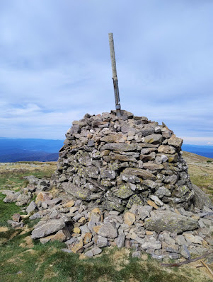
Cairn on the summit

View to the North East (Kosciusko is there somewhere)

Mountain Creek

Tasmanian Flax Lily (Dianella Tasmanica)
Snow Daisy (Celmisia Costiniana)
Grass Trigger Plant (Stylidium Graminifolium)

distance: 19.4Km  
moving time: 4hrs
elevation: 1419metre
 

Saturday, 30 November 2024

Mt Kembla - November 2024

Mt Kembla's summit, like the nearby Mt Kiera, is about the same altitude as the escarpment. Both these peaks extend east toward the coast from the escarpment cliff line, towards Wollongong suburbs. The path I took was fire trail, single track with some scrambling and a small section of road. From the top of the escarpment the country gently slopes to the west, this area is part of Sydney's water catchment.

 
Moss

Find the Monotreme

Lake Illawarra
Port Kembla
On the Summit Walk 
South along the Escarpment
In 1902 there was a massive explosion in the nearby Mount kembla Colliery. This explosion resulted in the deaths of ninety two miners, it is said to be Australia's worst industrial accident.  Nestled below Mt Kembla is the Windy Gully Cemetery, thirty three miners who perished in the colliery distaster are buried in this cemetery. Further information here; http://www.mineaccidents.com.au/mine-accident/184/mt-kembla-1902
 
Windy Gully Cemetery

 
distance: 9.1Km  
moving time: 1hr, 24min 
elevation: 306metre


Monday, 21 October 2024

Bullant Ridge & Florabella Pass - October 2024

Just a short one this time. From Blaxland to Bullant Lookout, and then back via Florabella Pass. Florabella Pass is a walking track which is high on the side of Glenbrook Creek Gorge. I emerging from the bush and onto the Great Western Highway a kilometer or so west of Blaxland. Having completed this with time to spare, so on the way home I stopped next the western bank of the Nepean River and hiked upstream to where Glenbrook Creek joins the Nepean River. The last two pictures were taken on this walk.

Glenbrook Creek from Bullant Lookout
Black Wattle (callicoma serratifia)
 
Hairy Wax Flower (philotheca hispidula)

Pink Spider Flower (grevillea sericea)

Looking upstream into the Nepean River Gorge
Glenbrook Creek confluence with the Nepean

distance: 10.7Km  
moving time: 1hr, 54min 
elevation: 409metre