The first part of this run was along Bruce's Walk. Bruce's walk follows the original power lines from Blackheath to Lawson. The power was generated at Lithgow further west, and this line transferred power east. Bruce's walk was constructed in the 1930's and has been very much neglected over recent times. Here is a wikipedia page on the walk
https://en.wikipedia.org/wiki/Bruce%27s_Walk. The rest of this excursion was along well known and documented walking tracks as well as the Mt Hay dirt road. Earlier on I had two close snake encounters, I guess these fellows were soaking up the last of the summer sun. After this I didn't hurry and made a lot of noise through the denser undergrowth areas, particularly where I couldn't see the path due the overhanging ferns, luckily I didn't see any more serpents, but who knows how many snakes I passed but I didn't see . Otherwise this was a most enjoyable but long day in the bush.
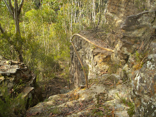
The original unmaintained handrail & path on Bruce's
Bruce's Walk at the Katoomba Creek crossing
A sign en route
Looking NW along Bruce's walk
The Grose River is in the valley in the middle of the picture. It is flowing east toward the Hawksbury river taken from near Lockleys Pylon
Looking down on Govetts Creek taken from near Du Faur Head
Du Faur Head is on the left, taken from Govetts Creek
The Junction of the Grose River & Govetts Creek
Log crossing of Govetts Creek
Yellow Slime Mould fuligo septica (dog vomit funghi)
Rodriguez Pass
violet juvenile leaves
Stats,
distance: 28.5 Km
moving time: 4hr, 48mins
Elevation: 1272 metres
Calories:2755


No comments:
Post a Comment