Tuesday, 31 December 2024

Mt Bogong - December 2024

Mount Bogong is Victoria's highest peak at 1986 metres, just 242 metres lower than Mount Kosciusko.  Kosciusko  can be seen from Bogong, approximately 90 km away. I was last on Bogong's summit carrying my son, he is now forty two, it would have been about forty years ago. On that occasion we did the Eskdale and Staircase Spur's loop, this time I went up and back via the Staircase, the shortest route from Mountain Creek Campground. It was a warm day and hot work climbing in the trees, once above the tree line the temperature was pleasant and on the top it was decidedly cool. I slept soundly that evening in the basic but beautiful Mountain Creek Campground. 

Above the tree line

Mint Bush (Prostanthera Subalpina)

Spot the snake (I sighted two)

Bivouac Hut

Looking into Keiwa Valley


Cairn on the summit

View to the North East (Kosciusko is there somewhere)

Mountain Creek

Tasmanian Flax Lily (Dianella Tasmanica)
Snow Daisy (Celmisia Costiniana)
Grass Trigger Plant (Stylidium Graminifolium)

distance: 19.4Km  
moving time: 4hrs
elevation: 1419metre
 

Saturday, 30 November 2024

Mt Kembla - November 2024

Mt Kembla's summit, like the nearby Mt Kiera, is about the same altitude as the escarpment. Both these peaks extend east toward the coast from the escarpment cliff line, towards Wollongong suburbs. The path I took was fire trail, single track with some scrambling and a small section of road. From the top of the escarpment the country gently slopes to the west, this area is part of Sydney's water catchment.

 
Moss

Find the Monotreme

Lake Illawarra
Port Kembla
On the Summit Walk 
South along the Escarpment
In 1902 there was a massive explosion in the nearby Mount kembla Colliery. This explosion resulted in the deaths of ninety two miners, it is said to be Australia's worst industrial accident.  Nestled below Mt Kembla is the Windy Gully Cemetery, thirty three miners who perished in the colliery distaster are buried in this cemetery. Further information here; http://www.mineaccidents.com.au/mine-accident/184/mt-kembla-1902
 
Windy Gully Cemetery

 
distance: 9.1Km  
moving time: 1hr, 24min 
elevation: 306metre


Monday, 21 October 2024

Bullant Ridge & Florabella Pass - October 2024

Just a short one this time. From Blaxland to Bullant Lookout, and then back via Florabella Pass. Florabella Pass is a walking track which is high on the side of Glenbrook Creek Gorge. I emerging from the bush and onto the Great Western Highway a kilometer or so west of Blaxland. Having completed this with time to spare, so on the way home I stopped next the western bank of the Nepean River and hiked upstream to where Glenbrook Creek joins the Nepean River. The last two pictures were taken on this walk.

Glenbrook Creek from Bullant Lookout
Black Wattle (callicoma serratifia)
 
Hairy Wax Flower (philotheca hispidula)

Pink Spider Flower (grevillea sericea)

Looking upstream into the Nepean River Gorge
Glenbrook Creek confluence with the Nepean

distance: 10.7Km  
moving time: 1hr, 54min 
elevation: 409metre


Monday, 9 September 2024

Mount Kooyoora - September 2024

First up was a visit to the White Swan Quartz Crystal Mine, this mine had two periods of operation, the first being in the 1920s, the quartz was then used on graves. The second period in the 40s the mine was made an "open cut", the crystal was at that time extracted for AWA to use in radios for the war effort. I then scrub bashed to the summit of Mt Koorooya. On the northern side of the mount is a huge granite rock face. This rock face is at least higher then one hundred metres. After the summit I followed the ridge west, eventually dropping to flat lightly wooded land and making my way back to the car the long way, this involved some "off piste", bush bashing. It was a nostalgic run back, passing the spring/soak where two mates and I camped around sixty years ago. In 1954 a small uneconomic deposit of Torbernite, an ore of uranium was found in the park. Next time I am here I'll have a look for it.

The White Swan Crystal Mine
Mt Kooyoora from the Crystal Mine

 Flowering throughout the park was, Wallowa acacia euthycarpa 

The ridge west from the summit

Swamp Wallaby

The Rock Face, the picture doesn't convey the height

The soak, where three lads camped

I would like to know how old it is.

distance: 16.1Km  
moving time: 2hr, 35min 
elevation: 350metre

Wednesday, 21 August 2024

The Emerald Pool & Mount Olive - August 2024

The Emerald Pool is a beautiful spot to have a dip in the warmer months, the water is pristine, it's catchment is wholly within the National Park. Like last month, this run is in the Popran National Park. The pool is only accessible by walking. Close to the car park is Mt Olive, it is not really a mountain, just a slight prominence above the surrounding bush. Normally there is a view from the summit, with the Pacific Ocean visible, only limited views today owing to the misty rain, fortunately it wasn't cold.

No view today due to low cloud

The Park Entrance

Donovan's Forest


The Emerald Pool

Mount Olive Trig


distance: 12.0Km  
moving time: 1hr, 53min 
elevation: 284metre
 

Saturday, 27 July 2024

Big Jim's Point - June 2024

This walk was in a not so popular section of the Popran National Park, just across the Hawkbury, from the Gentlemans Halt, the subject of my last bush trip. This track starts  approximately 60km north of Sydney, on the old Pacific Highway. The park was established in 1994. Some sections of this trek are along the Sydney Newcastle gas pipeline easement, these bits involved scrambling through dense scrub.

c
The start of the track was a little tricky to find.

High voltage transmission lines spanning the river.


This bulldozer was abandoned where it stopped, too expensive to recover.
 
Looking across at Gentleman's Halt, the old post office is visible.

distance: 12.3Km  
moving time: 3hr, 32min 
elevation: 394metre

Friday, 28 June 2024

Gentlemans Halt - June 2024

Gentlemans Halt is only accessible by boat, or bushwalking now. In previous times there was a whole community living there, with orchards and even a public school. The school was functioning in the period 1883 to 1901. In those times there was one road into the place, this road is now overgrown and not usable. 

It is believed the first white people to visit Gentlemans Halt was Arthur Phillip, John Hunter, and crew. They camped here 13th June 1789 on their expedition up the Hawksbury River. 

The school building has been extensively renovated and is now a private residence. Here is a link to the building in it's renovated condition; 1883 post office

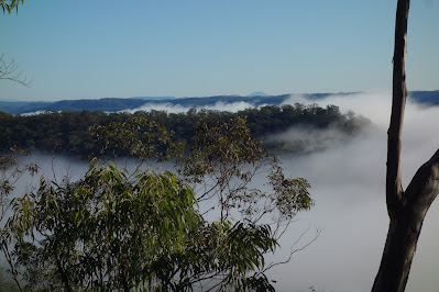
The Hawksbury River is in the far fog. Big Yengo is the flat topped mount on the horizon.

The community of Spencer over the river, Mangrove Creek in the top right


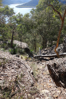
A more difficult section of the track with the Mangrove Creek confluence visible.


Mangroves on the edge of Gentlemans Halt

Gentlemans Halt the pointy bit, the river swings to right behind Gentlemans Halt. Mangrove Creek visible top left. 
Looking at the ridge the previous picture was taken from.
Gentlemans Halt campground.
 
distance: 25.5Km  
moving time: 4hr, 37min 
elevation: 834metre