There are various stories regarding the origin of these ruins, some suggest it was a hotel, others dispute this. Most agree it was completed in 1900, and habitable for twenty or so years when it was abandoned. Some of the graffiti on the walls is marked 1931. The site can be accessed by water and then scrambling up steep track, or walking down a sometimes steep and rough fire trail. National Parks have installed a gate at the entrance to the fire trail, blocking vehicular access.
b |
An extremely steep & rough section of track
|
 |
| A rusting Falcon at the bottom of the above section of track |
|
 |
| Berowra Creek |
|
 |
The Ruins
|
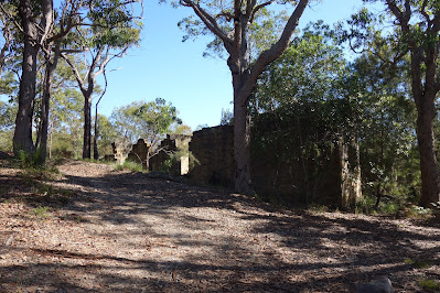 |
Another view
|
 |
| On the Berowra Waters car ferry |
Stats,
distance: 7.7Km
moving time: 2hr, 07min
elevation: 176metre


