Langi Ghiran or "Lar-ne- Jeering" to the Djab Wurrung people, means home of the black cockatoo. In 1836 Major Mitchell was the first European to climb the mount, he dubbed it Mt Mistake.
Part of Ararat's water supply the Langi Ghiran reservoir was built in 1880. The Mt Cole reservoir is approximately nine kilometers east of Langi Ghiran. A pipeline from the Mt Cole reservoir gravity feeds water to the ridge a kilometre or so from the Langi Ghiran reservoir, the water would then flow down the granite block lined channel to the Langi Ghiran reservoir. This channel is no longer used, a pipeline has been constructed for this purpose.
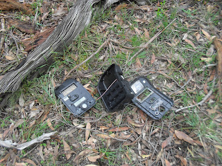
I started off from the picnic ground and camping area. Heading east and clockwise along a walking track, after passing the main reservoir I had planned to follow the disused open channel to the ridge where the the Mt Cole pipeline emerges, I had a little trouble locating the channel, so I was bushbashing until I picked up the channel. While I was trundling through this off track section, I came upon the smashed wild life camera pictured below.
From the pipe outflow point I was on closed off four wheel drive tracks to within a couple kilometers from the summit, then rock scrambling to the summit and thence to the hidden lagoon. The Hidden lagoon is in the saddle between the Langi Ghiran peak and the lesser peak of Mt Gorrin. From the lagoon It was an easy dirt track back to the car. Then the start of my long drive back to Sydney.
 |
| The First Small Dam |
 |
| A Granite Style near the Small Dam |
 |
| The Main Reservoir |
 |
| Somebody doesn't like being videoed |
 |
The disused open channel
|
 |
| Looking North from the Mt Cole pipeline outflow |
 |
| The Dry Hidden Lagoon |
 |
| Looking South From Langi Ghiran Summit |
Stats,
distance: 16.3Km
moving time: 2hr, 32mins
Elevation: 700metres
Calories:1574


