My plan was to have a look at the top of Bush rangers track, and if it wasn't too risky, go into the valley via this track. I knew there was a rope tied to a tree to assist getting down the first steep section. One look and I quickly abandoned that plan. Plan B was to pick up Bush Rangers track where it crosses the Kedumba Pass road further into the valley. The lower section of the track also has a small cliff that is negotiated with a chain, this was much easier than the rope on the upper section. After the farm and crossing the Kedumba river I headed for the eastern base of Mt Solitary and picked up the Solitary transverse track. I then headed back towards the Kedumba Pass, this involved an other river crossing, no wet feet this time, I could cross the river at this point on an old fallen tree. Once I hit the Kedumba Pass road it was just a matter retracing my steps to arrive at the Ute.
The Kedumba Valley was used in colonial times as a Bush Rangers hide out, hence the name of the track, the track is also called the Goat Track. This track was the only access to the valley prior to the pass road construction.
The Maxwell family farmed the valley, until it was taken over by the National Parks and the Sydney Catchment Authority.
The farm is the clearing in the middle, it is usually green, quite dry this year.
These two memorials are at a lookout on the top of the cliff
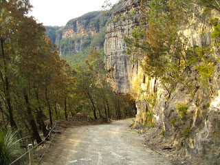
The Kedumba Pass just after leaving the Kings Table Land, the Goat Track head is just near the post on the left. Note the road carved under the cliff.
An orchid growing in a tree (Epiphyte)
At the farm, last time I was here I came across three Brumbies, no evidence of them this time.
The Kedumba River at the farm, I got wet feet here.
Stats,
distance: 17.8 Km
moving time: 3 hrs 3 mins
Elevation: 1143 metres
Calories: 1951


